

Riding the Monsoon: How Seasonal Winds Built the Indian Ocean Trade

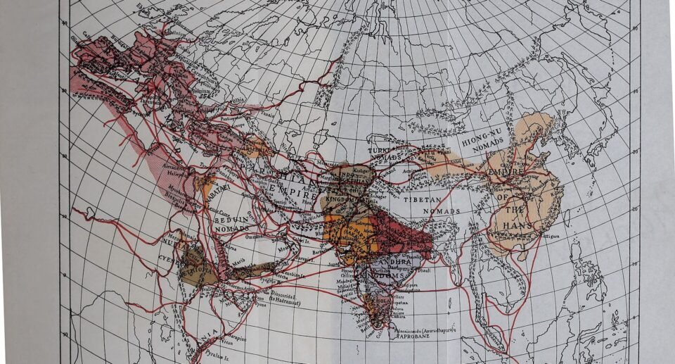
Every year, for about half the year, the winds over the Indian Ocean blow one way, and for the other half they blow the opposite way. Sailors learned to use this clockwork. They rode the wind east in summer, waited in port, and rode it back west in winter. That rhythm built trade between Africa, Arabia, India and Southeast Asia long before steamships, and it still decides whether a farmer in India has a good year.
| Meaning | A seasonal reversal of winds, from the Arabic word mausim (season) |
| Summer monsoon | Southwest wind, rainy, roughly June to September |
| Winter monsoon | Northeast wind, mostly dry except the southeast coast |
| Famous port | Muziris, on the Malabar Coast |
| Modern forecast | India has issued monsoon forecasts since 1884 |
| Reading time | 10 min read |
What a monsoon is
Land heats and cools faster than the sea. In summer, the huge land mass of Asia becomes hot and air above it rises, so cooler, moist air from the Indian Ocean rushes in to replace it. That gives the southwest monsoon, with heavy rain. In winter the land cools and the pattern reverses, so dry air blows from the land toward the sea, the northeast monsoon.
The southwest monsoon usually reaches Kerala in early June and covers the whole country by mid-July. It begins to withdraw in early September and the withdrawal is normally finished by early October. The northeast monsoon bursts around 20 October and lasts about 50 days, bringing winter rain to Tamil Nadu and Andhra Pradesh.
Try it: sail with the wind
Move the month slider. The arrow shows the main wind over the Arabian Sea, and the box tells a ship’s captain which voyage makes sense.
Distances show why the timing mattered. This Python code estimates sailing times for the Muziris to Red Sea route from straight-line distances. I ran it, and the output is real. Actual routes were longer and speeds varied, so treat the results as a rough guide.
import math
def hav(a, b):
    R = 6371
    la1, lo1, la2, lo2 = map(math.radians, (*a, *b))
    h = math.sin((la2-la1)/2)**2 + math.cos(la1)*math.cos(la2)*math.sin((lo2-lo1)/2)**2
    return 2*R*math.asin(math.sqrt(h))
P = {"Muziris": (10.21, 76.2), "Aden": (12.79, 45.04), "Berenike": (23.91, 35.47)}
for a, b in (("Muziris", "Aden"), ("Aden", "Berenike")):
    d = hav(P[a], P[b])
    for k in (4, 5):
        print(f"{a} -> {b}: {d:.0f} km, {d/(k*1.852*24):.1f} days at {k} knots")
Muziris -> Aden: 3405 km, 19.2 days at 4 knots
Muziris -> Aden: 3405 km, 15.3 days at 5 knots
Aden -> Berenike: 1595 km, 9.0 days at 4 knots
Aden -> Berenike: 1595 km, 7.2 days at 5 knotsTogether that is roughly three to four weeks of straight-line sailing, so the ancient estimate of about forty days for the whole trip fits well once you add coastal detours and stops.
The trade that the wind built
The Greek-Roman guide called the Periplus of the Erythraean Sea, written in the 1st century, describes ports along the coasts of the Red Sea, Arabia and India and explains when to sail. Roman writers credit a Greek pilot, Hippalus, with showing how to cross the open Arabian Sea directly by using the southwest wind instead of creeping along the coast. Whatever the exact history, by Roman times large ships made the crossing every year.
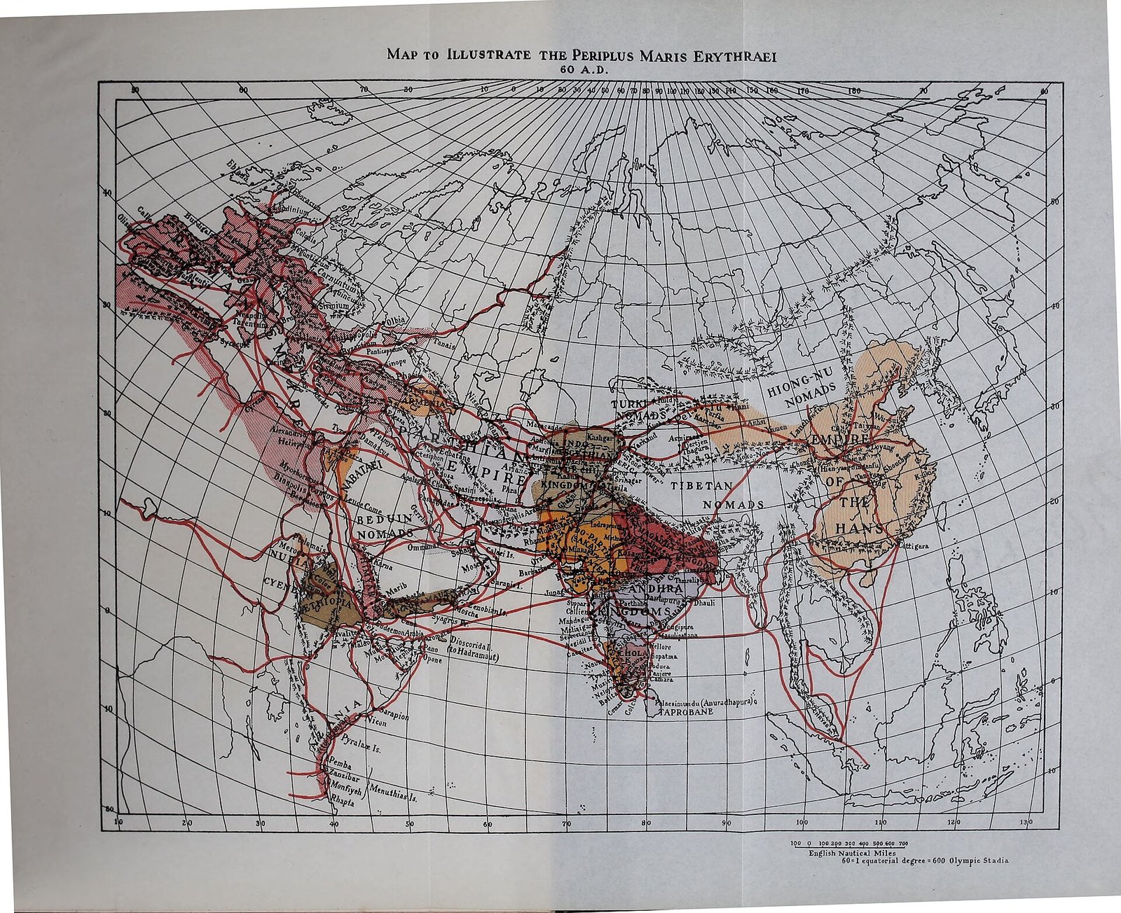
1st century: The Periplus is written
A sailor’s guide describes ports, goods and seasons from Egypt to India.
2nd century: The Muziris papyrus
A contract for a pepper cargo on the ship Hermapollon, valued at about 9 million sesterces.
1025: Chola naval expedition
The Chola king Rajendra I sends a fleet across the Bay of Bengal toward Southeast Asia.
1405 to 1433: Zheng He’s voyages
Chinese fleets use the monsoon to reach Calicut and beyond.
1498: Vasco da Gama reaches Calicut
European ships arrive by sea, with help from local pilots.
Muziris: a lost port
Muziris stood on the Malabar Coast of Kerala, near the mouth of the Periyar river. Pliny the Elder called it the first trading centre of India. Pepper, sometimes called black gold, was the main export, along with pearls, gems, ivory and fine cloth. In return the Mediterranean sent gold and coins, wine and glass. Roman ships anchored at the edge of the lagoon and cargo moved upriver on small boats.
Muziris vanished from maps, probably after severe floods on the Periyar river in 1341 changed the coastline, and silting closed the harbour. Its exact site is still discussed, and excavations at Pattanam near North Paravur have led many experts to favour that location.
The monsoon and India today
Roughly half of India’s land is farmland and more than half of that depends on rain. So the monsoon is sometimes called the real finance minister of the country: if it is late or weak, harvests, prices and rural incomes all feel it. Forecasts have been issued since 1884, and today the India Meteorological Department uses satellites, radars and supercomputer models to track the monsoon.
Climate research suggests that monsoon rainfall is becoming more uneven in many places, with more intense downpours between longer dry spells. This is an active research area and the details vary by region.
Mind map: the monsoon world
- Monsoon
- Winds
- Southwest: June to September
- Northeast: October to December
- Land and sea heating
- Sailors
- Periplus
- Hippalus
- Dhows
- Ports
- Muziris: Kerala
- Aden
- Berenike: Red Sea
- Calicut
- Goods
- Pepper
- Pearls and gems
- Cloth
- Gold and wine
- Today
- Farming
- IMD forecasts
- Climate change
- Winds
Myths worth correcting
- Myth: Ancient sailors simply followed the coast. Fact: by Roman times ships crossed the open sea using the monsoon.
- Myth: The monsoon is only rain. Fact: it is a seasonal wind system, and the rain is one result.
- Myth: The monsoon arrives on the same day every year. Fact: early June at Kerala is typical, but it varies by days or weeks.
Key takeaways
- A monsoon is a seasonal reversal of wind caused by land and sea heating differently.
- Traders sailed east with the southwest monsoon and returned west with the northeast wind.
- Muziris in Kerala was a major pepper port that traded with Rome.
- The monsoon decides harvests and economies in India today.
- Distances and ancient texts agree that the route took weeks, not days.
Frequently asked questions
Where does the word monsoon come from?
From the Arabic mausim, meaning season, because Arab sailors tracked the seasonal winds.
Who was Hippalus?
A Greek pilot credited by Roman writers with showing how to use the monsoon wind for a direct sea crossing to India.
Why do Tamil Nadu and Kerala get rain at different times?
Kerala gets most rain from the southwest monsoon, while Tamil Nadu gets much of its rain from the northeast monsoon in October to December.
Why is the monsoon important for farmers?
More than half of India’s farmland depends on rain, so timing and amount affect crops directly.
Keep reading
The instrument that helped sailors find their way.Mercator’s Map
A map made for sailors.The Invention of Farming
How rain and rivers shaped farming.Maps Lab
Explore India, the world and a 3D globe.
Sources
- Monsoon of India, Wikipedia, seasons, onset dates and importance
- Muziris, Wikipedia, Roman trade, the papyrus and decline
- Monsoon, Encyclopaedia Britannica, how monsoons work
- India Meteorological Department, official weather and monsoon information
Facts were cross-checked against these pages and rewritten in our own words. Sailing times are estimates from straight-line distances.


3 Comments
[…] to measure the height of a star. You can read more about the winds that powered these voyages in our guide to the monsoon and Indian Ocean trade. When Vasco da Gama reached East Africa in 1498, he took a local pilot to guide the crossing to […]
[…] Monsoon trade winds: The Indian Ocean highway. […]
[…] CompassThe instrument that made Mercator’s map useful.Riding the MonsoonHow sailors used the winds of the Indian Ocean.Maps LabOur interactive India map, world map and 3D globe.Mind Map hubSee navigation in the bigger […]